

This is pretty interesting! I like the bits where they show the 1950s aerial view vs the present ones to show how the river changed.
That’s really cool, thanks for sharing! I don’t see that many long form articles these days.
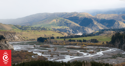
It’s something I haven’t thought about. We build flood banks higher but we could go twice as wide instead of twice as high.
That was the maths I was working with too - but seemingly there’s two parts to it, capacity between the banks and flow rate of the river in flood and for the latter wider is better.
So presumably you can build lower, cheaper stop banks further apart for slower flood velocity and less risk of stop bank failure at the expense of more risk of stop bank overtopping.
A lot of the land lost since the 1950s upstream of Fernhill isn’t exactly top quality stuff, but allowing the rivers to meander downstream from there will likely mean some folks have to give up some pretty valuable & fertile land. Better that than continuing to get flooded out given repeat Gabrielle’s are more likely.
The land is likely fertile because of the flooding. I wonder if there are opportunities to split the difference and farm the land (say, with fruit trees) while having the flood banks built much further from the river, just accepting the land will be flooded from time to time.
From what I understood of the article one of the issues is that the vegetation - particularly willow - causes sediment buildup and soil comes in over top of the gravel bed. That suggests to me that the soil isn’t particularly deep and in a Gabrielle level flood could see anything planted in that deliberate flood zone ripped out and shifted down to the next bridge.
In most of those “reclaimed” areas especially upstream of Fernhill the land is pretty scrubby and I would guess not especially good horticultural land. But downstream from there where the stopbanks have protected it for so long I think there’s a much deeper bed of soil - probably by that point the rivers would ordinarily have been going much slower so less often gouging out the dirt.
It obviously adds up in cost because of the overall land area, but my dumbies math does sort of suggest the benefit in retreating stopbanks 15-20m either side would mean being able to contain that much greater volume of water during floods, reducing risk of overtopping.
Ah I didn’t think of the risk of the orchard trees all being swept up into a missile to hurl at bridges. Maybe the answer isn’t to try to widen the river, but instead split it. Allow it to fork off and have multiple channels. Maybe even breaking off streams upriver to prevent the river rising so much.
Although I guess the point of the article is that we shouldn’t mess with the river so much 😅
Yeah I spent a day helping clear up at an orchard after Gabrielle and there was a whole field where some younger trees were all just gone. I think what had happened in a lot of places was debris from upstream just washed through at velocity and broke everything above ground level away then pushed it down until it hit a barrier it couldn’t get over or around.
And in some places, where that barrier was a bridge the weight of water & debris was enough to wash that away too.